LK8000 and XCSoar on an Unmodified Kobo Mini

This is a guide on how to run LK8000 and XCSoar on an unmodified Kobo Mini. This should work on the Kobo Touch and Glo model as well.

Shopping List

You will need the following parts:

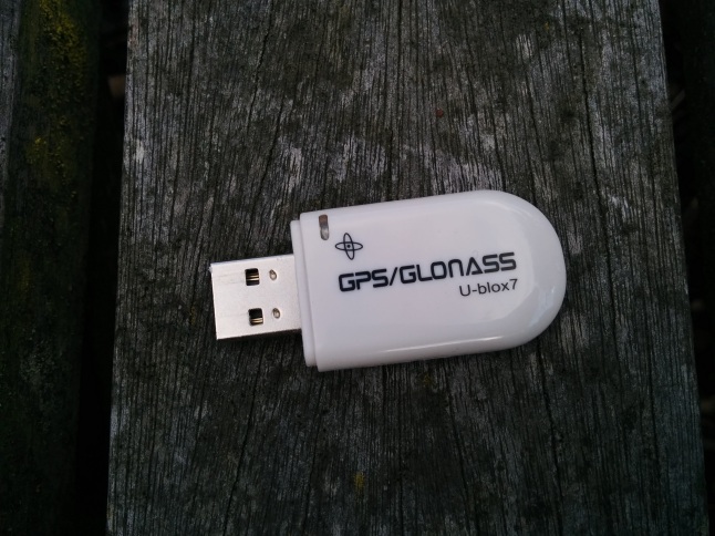
  • USB GPS dongle capable of outputting in NMEA format. I have used a U-blox7, which I bought from ebay for £10 here.

IMG_20160621_190414

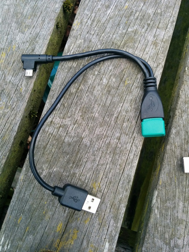
  • Micro USB OTG cable with a Y-split for power input. You need the split cable as unfortunately the Kobo USB doesn’t supply power to the GPS. There are some really cheap ones on ebay but I went with a slightly higher priced and higher quality one. I think it is important to get a 90 plug on the Kobo end as it helps to protect the socket more. The USB socket on the Kobo is pretty weak so it is important to protect it as much as possible. The one I bought cost £6 and can be found on ebay here.

IMG_20160621_190406

  • USB battery pack. You need this to power the GPS, but it also charges the Kobo at the same time so the battery lasts ages! I use a tiny 3000mah battery and after 12 hours the Kobo was still at 100% and the battery had more than half it’s charge left. It is important to get a simple battery pack with no power button as these switch themselves off when they detect that a device is fully charged. I used this one from Aukey for £6.99 and it has been perfect. Obviously you can use bigger battery packs but I am just showing that you don’t need to.

Edit: It has been pointed out that the design of the battery pack that I used may have been changed. The version I have has no switch for on and off but a version that someone else bought has an auto cutoff and the charge indicator also turns off the charging. The amazon page still indicates it has no power switch so if you order one and it does you are well within your rights to return it for refund.

Plug it all together and it looks like this:

IMG_20160621_190247

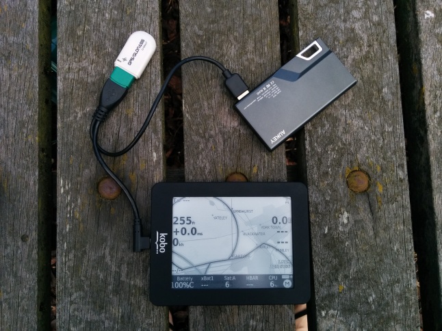
You can easily tuck the battery pack and dongle into your flight deck and you will be left with a nice neat install.

Software Installation

This setup works with both XCSoar and LK8000 so you can choose your favourite software. I personally prefer LK8000 as it is more geared towards the needs of paraglider and hang glider pilots. If you fly competitions then LK8000 is a must as it is the only one that does start cylinders properly.

LK8000

  • Download the latest release of LK8000 from here (currently 5.3U).
  • Unzip the downloaded folder and you will find the Kobo-install-otg zip file inside. You need to unzip this into the root directory of the Kobo.
  • You should end up with an LK8000 folder and a file called KoboRoot.tgz in the .kobo folder. It is important that you have both the LK8000 folder and the KoboRoot.tgz file  on the Kobo or it won’t work.
  • Eject and unplug the Kobo from the computer and it will display updating on the screen for a short while and then boot into the LK8000 start menu.
  • Click ‘fly’ on the menu and plug in the gps dongle and battery as shown in the photo above.
  • Wait for the GPS to lock on to a signal (indicated by flashing green led on this dongle).
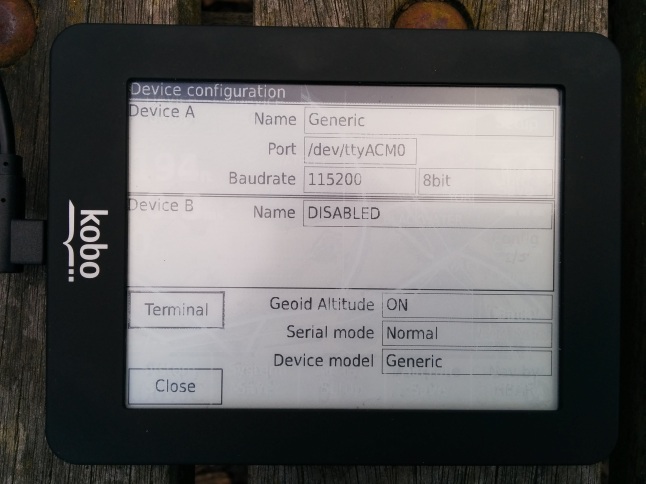
  • Go into the device settings and use these settings:IMG_20160621_190515
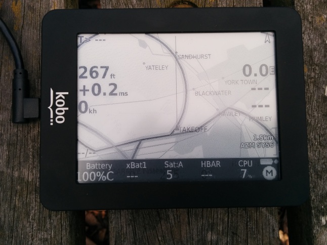
  • Click terminal to check if the GPS is sending data to the Kobo. It should look something like this:IMG_20160621_190528
  • Exit out of the settings and you should now have a working GPS!IMG_20160621_190325.jpg

XCSoar

XCSoar is exactly the same process of install and setup as LK8000 except that OTG is enabled in the startup menu instead of installing a special version. The option you need is here:

IMG_20160620_175104

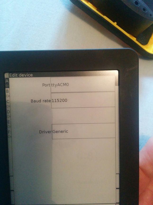
The port settings are identical to LK8000 also:

IMG_20160620_175136


Early testing seems to show that this setup works reliably and produces a clean track. I have yet to try it in the air but will update when I do.

I want to say a massive thank you to Bruno de Lacheisserie from LK8000 for helping me to get this working on LK8000. Hopefully this will help more people to benefit from the excellent combination of LK8000 and Kobo.

First XC From the Forgotten Site

After watching everyone else fly xc after xc whilst I was busy at work I finally caved in and booked a last minute day off. Conditions were forecast to be ok for xc flying but not too epic locally. I briefly flirted with the idea of driving to the Malverns but it would have been a very long and expensive drive on my own. I decided to head to Chalton, our rarely used local easterly site.

Chalton is smaller than Mercury or Whitewool and has a lot of trees on the slope. It did have a lot of thorny bushes covering the top and slope but a scrub bash a few years ago cleared a lot and the farmer topped the hill at the beginning of the year. It is still not as friendly as the other two sites but it is greatly improved from the past. Another improvement we have made is to the parking arrangements. The site guide has previously recommended parking in a layby at the bottom of the hill and walking up, quite an unpleasant walk! We have found it easier to park next to the pub and walk through the churchyard and across the top of the hill to launch. This has the added advantage of every flying day ending at the pub.

I arrived at the hill alone at about 1030, usually I don’t like flying alone but it is a common occurrence at Chalton. As I got my kit ready I could already feel thermal cycles coming through and a few cumulus forming in the distance. I took off and immediately found the air to be quite rough with the thermals very sharp edged. A symptom of higher pressure more stable air.

I found some good thermals in amount the chop and a couple of times found myself 700ft above take off and dreaming of leaving the hill. Everytime the thermal bubble would fizzle out and I would drift back down to the ridge. I spent a lot of time scratching the trees for lift and even caught a full frontal on the brakes just as the leading edged started to give way (not pleasant when flying at treetop height). The scratchy conditions meant that I had made the walk up from the bottom of the hill several times by the time RJ turned up at 1230.

Image

Conditions continued to tease the both of us for another hour before I found a more solid thermal over the road to the north of take off. As I became to circle up I saw RJ screaming across the ridge on full bar to join me.

RJ caught me up as I hit a max altitude of 3000ft asl in a blue sky. The drift was to the south west so we decided to head for the coast rather than our previous goal of Whitewool. With weak thermals and a blue sky I decided to take it slow and milk the lift as RJ steamed off in search of something better. Unluckily he found nothing and landed near Denmead for 11.5km.

Image


Image

I took a more southerly track staying over urban areas and managed to find another climb with took me to the high point of the flight, 3428ft. I glided for the clouds to the south of me and arrived above them!

Image

The wind was pushing me towards the radar on Portsdown Hill and I didn’t fancy having my nads fried so I crosswind towards Portsmouth. I didn’t have enough height to cross the built up area safely so I elected to land on Portsdown Hill safely away from the radar! I made 14.5km in the end, setting the Chalton XC record by default as no one had been xc from the site before! I think with a proper easterly or even ese wind and good xc conditions it should be possible to push north around Southampton airspace and onwards to proper distance.

Image

Image


New Wing!

I’ve bought an Advance Sigma 8 and I love it! It looks awesome in blue and it feels very much like the Gin Sprint except it turns flatter and really shifts on bar. The Gin Sprint has gone to a new home. I will really miss that wing, it looked after me and took me to some incredible places.

Video

Go Places – My Paragliding Adventures So Far

Over the long long winter I have set myself a challenge of going through all my old Gopro footage and making a compilation video showing all the amazing places that paragliding has taken me.

Spurred on by last years Wessex Club video competition, I have discovered that shorter videos are far more entertaining. No one wants to watch 30 minutes of someone ridge soaring the local ridge! I have decided to limit myself to 3 minutes unless I have a good reason to go longer (a story to tell or an instructional video).

To make it extra hard for myself I had chosen Isla de Encanta by the Pixies as the music for the video, a fast paced number that only lasts 1:41! Squeezing nearly five years of paragliding experiences into that time has been very tough and time consuming but I’m proud of the result…

Skysurfing Club Parachute Repack Day

It is that time of year again. Time to repack the reserve you hope you will only see again in a years time at the next repack. I have a new reserve this year, a Sup Air Light. Compared to my Gin One G it is harder to fold but worth it for the massive weight and bulk saving. No problems with the packing from the factory but always nice to be carrying something you have repacked yourself.